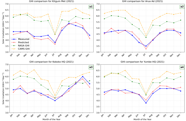
The project successfully developed a machine learning model to predict daily Global Horizontal Irradiance (GHI) in Sub-Saharan Africa, with a specific focus on Uganda. The core objective was to correct the systematic bias found in readily available satellite-derived solar irradiation data (like NASA CERES and CAMS). Key activities included identifying five installation sites in Uganda for ground-truth data collection (Gulu, Mbale, Jinja, Kasese, Hoima), procuring pyranometers (though installation was hindered by lack of Ministry of Energy approval), and extensively collecting data from four satellite sources and partner ground stations (Cross Boundary Energy, Makerere University, Ministry of Energy) combined with local topological information (ie. altitude). A Random Forest model was trained on this integrated dataset, proving superior to other models (LSTMs, SVMs) by effectively adjusting the satellite predictions to align with the ground truth across all climatic regions, thus providing a significantly more reliable and bankable estimate of solar resources essential for rural electrification planning.